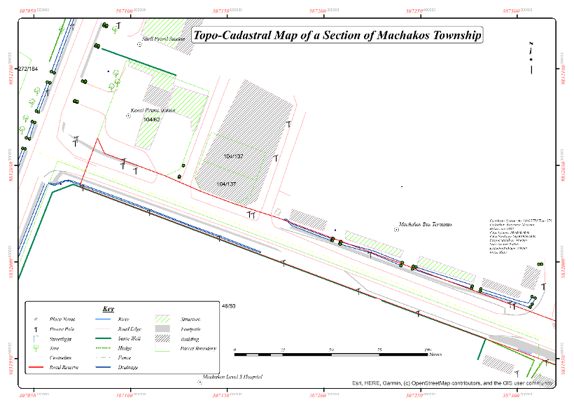
The Kenya National Highways Authority (KeNHA) is tasked with the responsibility of developing, rehabilitating, managing, and maintaining all National Trunk Roads, which include Classes S, A, and B roads, in the country. This mandate is aimed at enhancing socioeconomic growth and prosperity. However, a significant number of road reserves, including the Machakos – Syongila (B62) road section, have not been surveyed. Additionally, during the construction of the road, land was acquired, but despite compensation, most of it has not been registered, nor was surveying carried out to excise the part of the road reserve acquired. Consequently, road reserves are prone to various conflicts, including encroachment and pressure from different land uses such as agriculture and commercial activities. These conflicts raise concerns about the future of highway road infrastructure development in Kenya.
To address these challenges, KeNHA contracted GEODEV (K) LTD in August 2022 to provide consultancy services for a road reserve survey and title survey of the Machakos – Syongila road, which is a section of the B62 road covering 94 Km, including sections of the old road, which is 8 Km long. The consultancy services entail surveying and delineating the road reserve for the road section, including visible utilities, placing beacons, preparing mutations, causing registry index maps and preliminary index diagrams amendment for the acquired properties and remainder of the parcels affected by subsequent land acquisition, carrying out the title (fixed) survey, and preparing deed plans for the delineated road reserve and submission to the Director of Surveys (DoS) for approval.
The letter of award was issued on 27th July 2022, and the consultancy services commenced on 14th October 2022. The contract duration is fourteen (14) months, and it is expected to end on the 13th of December 2023.
Project Objectives
The project’s specific objectives necessitated that the Consultant obtain pertinent historical information, conduct requisite investigations and survey computations, establish horizontal survey control points along the project road, analyze design drawings, as-built drawings, land acquisition drawings, land acquisition information/gazette notices, and survey plans, survey the road reserve, including identifying existing road centerline and edges, fences, marker posts, and visible utilities (such as power lines, pipelines, main water pipes, sewer lines, fiber optic cables, etc.), survey each parcel listed in the relevant gazette notices (and any other relevant notices/information that the Consultant may find pertinent) to excise acquired land, delineate the final road reserve boundary of the road section after integrating road design/as-built drawings, cadastral plans, road data, ground survey, and land acquisition information, carry out a title (cadastral) survey of the entire delineated road reserve (including the old road sections) and quarry/material sites acquired for the project road development, and develop a GIS database for the entire road reserve section.
Benefits of the Project
Among the benefits of the project are Enhanced road safety for both road users and residents and ease of management of the road corridor by the relevant road agencies to in turn reduce cases of encroachment by other economic activities.
Scope of the Project
The project comprises approximately 94 km length of the B62 road and approximately 8km of the old road.
Location of the Project
The project road traverses Machakos County and Kitui County, starting at the Machakos-Wote (B60) junction next to the Machakos Level 5 Hospital and ending at the Syongila (A9) junction in Kitui County.
It passes through Kaseve Market, Masii Town, Wamunyu Town, Katangi Town, Kwa-Vonza Town among others.
Client
The project is for the National Government through the Kenya National Highways Authority (KeNHA) under the Ministry of Roads, Transport and Public Works.
2022
Kenya - Machakos/Kitui County
2023
94 km2,
Kenya National Highways Authority
0712151779
office@geodev.co.ke